Warning: Undefined variable $doc_root in /home/theshieling/public_html/tourist/walks.php on line 38
Warning: include(/masthead.php): Failed to open stream: No such file or directory in /home/theshieling/public_html/tourist/walks.php on line 38
Warning: include(/masthead.php): Failed to open stream: No such file or directory in /home/theshieling/public_html/tourist/walks.php on line 38
Warning: include(): Failed opening '/masthead.php' for inclusion (include_path='.:/opt/alt/php81/usr/share/pear:/opt/alt/php81/usr/share/php:/usr/share/pear:/usr/share/php') in /home/theshieling/public_html/tourist/walks.php on line 38
Guided Walks led by Cotswold Voluntary Wardens
Discovering the joys of a walk with the Wardens
By A. Barrett
 The shadows of trees and hedges are longer at this time of year and the sunlight is softened to a honey colour, but otherwise the 30th September this year could have been a July midsummer’s day-blue sky, high white clouds, temperature in the 20⁰C and the trees barely touched with golden or red as we set off from the Plough Inn with Cotswold Wardens Alison and Julie. This was a ten mile, figure of eight walk whose upper and lower loops crossed for lunch in the pub garden where a pint of Donnington’s from the local brewery down the road gave strength for the afternoon. As we waited for lunch at the pub doorway, a lady told me she had celebrated her 89th birthday that week. “I used to do those walks, ten miles easily, but now I can only do a mile or two.” But she was a fantastic advert for the life enhancing walks which the Cotswold Wardens lead.
One of the Wardens lived locally and we stopped in a lane to greet Irene and her dog, and later at a farm to warn John that we had passed a sheep in distress. We looked over the wall at lovely manor house gardens, into the local church where huge harvest festival carrots decorated the pulpit, saw giant puffballs and carpets of white and pink cyclamen beside a sunken pathway overarched with hedges and revelled in the wide open views over the hilly countryside. And as we wove along paths cleared by members of the Wardens’ working groups or across bridges and walkways maintained by them, there was a hum of conversation amongst us as old hands and novices shared stories and walking experiences and local tips.
This week we were a large group – a bit of a record because we all wanted to snatch the last days of summer – but more usually there are 10-20 for the walks, which continue all the year, up to four times a week. Two Wardens lead each walk and take care of all the practical details, checking the walk out a few days before to make sure all is in good order. They ensure that no-one gets lost or misses any of the interesting features of the countryside around. There is no charge for the walks but a donation of the ‘price of a cup of coffee’ is a modest contribution to the work which the Wardens do.
If you are new to the Cotswolds you will discover wonderful country, receive lots of good local advice and meet interesting people – single people, couples and small groups of friends mix very sociably. If you are a long-term resident, you don’t need to be reminded what a great job the Cotswold Wardens do. Details of all walks are given in the Cotswold Lion or on the website Escape to the Cotswolds. Do put them in your diary before all your other commitments crowd out this pleasure.
Click here to go to the Cotswold Walks Website for details of the latest and previous guided walks.
Please submit any local walks that you think others may enjoy, starting from Beckford - email Andy with full details.
Please visit the walk4life website for more local walks - you can even add your own walks!
Walks by Jack Walker (taken from Tewkesbury Direct Magazine)
The following walks have been published in the Tewkesbury Direct free magazine from time to time. This free magazine includes a regular feature of walks called 'Rambling Around' with Jack Walker.
Reflections of a Bygone Age - Jack Walker
 It is hard to imagine, while walking through this quiet and idyllic corner of rural England, that the streams which tumble down from the hills above once drove as many as six mills. Between the 18th and 19th centuries silk, paper and flour were produced here, and the population was twice what it is today.
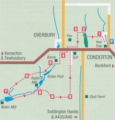
Our walk begins and ends in the mellow stone hamlet of Conderton, one mile west of Beckford. Starting from the Yew Tree inn, walk up the lane and bear left at the fork in the road up Water Grip Lane: it's easy to see how this got its name!
Look for the stile on your left (1); cross this into a farmyard, walk ahead and go over a low wall into an orchard. Cross the stile ahead of you and walk over the field towards a wood. Go over the stile and bear right along a path to the end of the trees. Do not cross the stile into a paddock. Walk past it and into a field (2), keeping the hedge on your left until you see a gap which leads through to a playing field (3). Walk down the field and around the perimeter beneath a row of trees to leave it via a track on to a road. Cross over, turn right and walk past the old shop, looking out for a way marked footpath on your left (4). Take this grassy path, which passes some old stone barns, then bears right along a wooden fence.
Cross over the tarmac track and a grass verge to reach a kissing gate into a field (5). With the still waters of the Brake Pool visible to the left, walk diagonally towards some oak trees and cross the stile behind them into a small patch of rough ground, over another stile and on to a footbridge - which is quite often slippery. Cross another stile into a field and head for a further footbridge over a ditch (6) and walk on through a five bar gate. Head down the next field to the gate in the corner, where a stream rises on the left (7). Go through the trees and bear left, with a stone-bedded brook flowing on your left. Cross over a bridge and ahead across a weir, over the stile and into a field.
Keeping the stream to your left, aim for a hollow tree and go through a kissing gate. Keep following the stream until you reach a track which leads to Robin's Mill (8).
The path here is way-marked into a small paddock. Walk over this and the next field, bearing right to a gate in the corner (9). Cross the stile in the hedge, turn left on to a track and then right through a five bar gate. In the field, turn left and keep along the hedge until you reach a stile over a wooden fence in the corner of the field (X). Take care not to disturb the horses and foals which abound here. Cross the stile and walk up the field keeping the hedge on your left. Go over two more stiles, keeping the fence on your left until you reach School Lane. At the T-junction, turn right and walk back along the road to Conderton.
-
Car Parking - with care, in the narrow lane adjacent to the Yew Tree Inn.
-
Distance - 2.75 miles; easy terrain. Can be fairly muddy near the streams after rain.
- Refreshments - the Yew Tree, Conderton. Now under new management and welcoming to walkers - they even fed my dog! Excellent ales and a good selection of meals and snacks; nice secluded garden at the rear of the pub.
A Land of Contrasts - Jack Walker
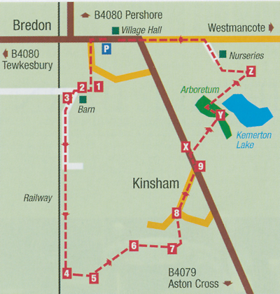 In spite of its close proximity to Tewkesbury and much expansion since the 1960s, the village of Bredon retains a good deal of character and enjoys a peaceful location between the River Avon and Bredon Hill.
The walk takes us from Bredon through pasture and woodland and is almost entirely flat; it can be muddy in places, particularly near the numerous farm gates It might be handy to take OS Sheet 190 with you, although the route is way marked throughout with yellow arrows.
From the public car park turn left and left again into Blenheim Drive. As the road curves left, look for the public footpath sign opposite and follow it up a short gravel drive and through a metal gate.
Bear right (1) and walk through a kissing gate along a path behind some sheds. Cross over some steps on the left (2) and walk ahead, keeping the barn to your left towards a track coming over a railway bridge.
Turn left along the track with the railway line on your right (3).
Keep straight ahead on the track next to the railway, through two gates/stiles, eventually reaching a field. Keep the embankment to your right and walk straight to the end of the field where you will meet a footpath coming down from the right. Turn left, keeping the hedge on the right, and go through a gate into a small field (4).
Walk up to a foot- bridge over a stream on the right, but do not cross it. Follow the left marker arrow (5) to guide you up the side of the field through a gate and on to a track with a house ahead of you. Look for a metal gate on the right (6), go through it and walk diagonally right across the field to reach another stile (7).
Cross over the stile and into a small birch plantation, noting the tree house ahead of you. There is an old stone post marking the way from here: follow the left hand arrow around a garden to reach a drive, emerging into the village of Kinsham. (8).
Walk up the lane (ignoring the turnings to the left and right) to pass the brick-built chapel, restored in 1904. On meeting the B4079 Cheltenham Road cross with care and bear left along the pavement (9). After a short distance turn right into a field (X,
sp Westmancote) and walk along the edge until you reach a wood. This is an arboretum managed by the Kemerton Conservation Trust and is part of the Kemerton Lake Nature Reserve. Go into the wood and turn left (Y) on to a path through the trees, and then right through a metal gate to reach Kemerton Lake. Go straight ahead, passing the chair sculpture, then through a small wood. There are hides to the right which afford views over the wetlands, a habitat for both migrant and resident wildfowl. The path emerges into a field with a hedge to the right. Walk along the track until you see a footpath going off to the left (Z). Take this path which eventually joins a drive leading past a nursery. On reaching the road, turn left and walk back into Bredon village.
-
Car Parking - Public car park in the village of Bredon, opposite Village Hall.
-
Distance - 3.26 miles, flat. Muddy In places, some lying water after rain. Suitable footwear recommended.
- Refreshments - The Fox and Hounds, Bredon (restaurant and bar snacks).
A Wander Around Westmancote - Jack Walker
 This month's walk visits Westmancote, one of the lesser known Bredon Hill villages with its own unique character - and an often bypassed curiosity.
The route begins in the centre of Kemerton, taking the war memorial as a starting point. Walk up the lane in the direction of Overbury, passing the Village (or Victoria) Hall on your right. As the road bears right, keep straight ahead up Hill Road (1) with converted barns and a high wall to your right.
Pass both entrances to Bayliss Road and keep climbing until you reach Daffurn's Orchard on your left. Pass this and go through the gate ahead of you (2) on to a rough track. Keep climbing the hill until you see a footpath to your left (3) along the edge of a field. Take this path, keeping the hedge on your right. There are good views across the vale beneath you and back to the Cotswold edge (see picture right). Eventually you will reach some cottages on your left and meet a lane which leads up onto Bredon Hill (4). Turn left and follow the lane all the way down through Upper Westmancote.
There are views to the right towards the Malvern Hills. As the lane flattens out look for the old chapel at the edge of the upper part of the village, and a gap into a field. Turn on to the footpath with the hedge on your right (5) and as this bears right walk diagonally left across the field to reach a kissing gate. Go through the gate on to a narrow path and look over the hedge on your left. Here a miniature railway, with its own little station, runs through extensive private gardens. In more than twenty years of knowing this place, I have never seen trains in operation and these days it does seem a little overgrown - but fascinating nevertheless.
At the end of the lane you will meet the road near Bredon Sports Club (6). Turn left and follow the road with care (no pavement) passing houses on your left until you reach a junction. Turn right here and cross over the road to take a footpath opposite the bus shelter (7). This narrow wooded path takes you past old allotment gardens and a free range chicken enclosure before emerging into a plantation. Keep straight ahead until you meet a rough track, turn left and look for the kissing gate opposite you (8). Go through the gate with the trees on your left and follow the way markers across this large grass field. This is part of the old Kemerton Park: Kemerton Court can be seen ahead through what remains of an avenue of trees. Please keep dogs on leads here as sheep and cattle often graze the pastures. At the end of the field go through the gate and cross the road, then turn into a small orchard (9). The wide variety of apples grown here are used for making organic fruit juice. Cross the orchard, go through the gate and turn left on to the road and return to the centre of Kemerton village.
- Car Parking - in the centre of Kemerton Village (have consideration for the residents)
- Distance - 2.5 miles, one moderate ascent between points 2 and 3. Otherwise flat.
- Refreshments - The Crown Inn, Kemerton. Good range of snacks, bar and restaurant meals. Patio garden, dogs welcome in bar area.
Washbourne Wandering - Jack Walker
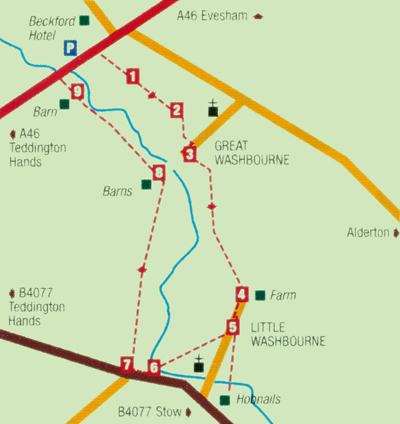 The tiny, twin villages of the Washbournes are tucked away in a little-visited pocket of farmland which lies between Dumbleton, Bredon and Oxenton Hills. Both Great and Little Washbourne are on the road to nowhere - so are not the best known places in Gloucestershire. Even the paths which will lead us there on our walk can be overgrown, though they are clearly waymarked by yellow arrows.
Park your car in the broad lay-by which is parallel to the A46 just before the turn for Beckford and Alderton. Cross the busy trunk road with care by the emergency telephone, and go through the gate,following the yellow arrows which mark the whole route, via various gates across a series of small paddocks.
Eventually you will emerge into a larger field with a hedge on the left. At the end (1) turn left and then right into an arable field, walk with the hedge on your right and continue straight ahead towards some buildings.
Emerge into a yard which belongs to Allbutt Manufacturing, (2) cross the lane, take the path opposite on to a drive, past some cottages and into
Great Washbourne.
If you wish to visit the 12th century church, turn left up the lane a little way and go up the steps. To continue the route turn right, then left (3) at the signpost through two small fields, taking care not to disturb the cattle.
Follow the arrows across open fields, with views to Dumbleton Hill to the left and Oxenton to the right. Follow the line of trees ahead and continue to Little Washbourne, emerging onto a track (4).
Turn right and walk with a barn on your left to enter the tiny village. (To visit the Hobnails Inn, take the left hand path which leads to the rear of the pub.)
Walk along the lane and go through a gate into an orchard (5). The beautiful redundant Norman church of St Mary, now managed by the Churches Conservation trust, is on the left. There is only one grave in the churchyard, as the ground is waterlogged. It is reputedly the last resting place of a boy, who is said to haunt the centuries-old Hobnails Inn.
Walk ahead to reach a footbridge (6) and emerge on to the busy B4077. Turn right for a short distance, then right into a large field (7). The path now turns back towards Great Washbourne, and Bredon Hill can be seen rising up straight ahead. To your right, behind a wire fence, is a brook which caused severe flooding of the meadows here in 2007. This stream will be to your right all the way back to Beckford.
At the end of the field, go through a gate and carry on towards some barns. Cross a lane (8) and walk through another gate, with the barns away to the left.
Follow the right hand edge of the fields until you meet the brook on the right, and walk under a small grove of trees until you see some farm buildings to the left. Go through the gate just to the right of the red brick barn (9) and walk straight ahead across the next field aiming for a white cottage ahead of you. Go through the gate and out on to the A46, turn right and walk with care back to the car.
- Car Parking - Layby, A46 before the Beckford turn, near The Beckford Inn.
- Distance - 3 miles, flat. Can be overgrown with uneven ground in places.
- Refreshments - The Hobnails Inn at half way point is ideal. Famous 'giant bap' and restaurant menu, garden. Good choice of ales.
Along the Ridge - Jack Walker
As the days get longer and Spring is in the air, the opportunity for longer walks presents itself. This route, although a little more strenuous than some of our walks, takes in varied terrain and offers some stunning views. It can be traced on OS map 190.
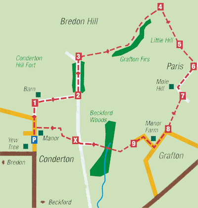
Park with care in the road at the side of the Yew Tree Inn at Conderton. Walk up the street away from the village, passing the manor house on your right. The lane climbs up Bredon Hill. with a stream down to your right.
As the road bears away to the left, carry straight on up a rough track. Follow this as it curves steeply up to the right, ignoring the bridleway to the left. You will pass a barn on the left (1). As the lane flattens out, to the right there are good views over to the Cotswold escarpment, with Cheltenham and the Vale of Gloucester in the distance.
Keep walking straight ahead until you meet a lane coming up from the right. Go left, (2) following the blue bridleway markers, passing through a small coppice. The remains on an old quarry lie down to the right.
As the bridleway emerges from the trees, turn right along a permissive path (3). This will take you along the ridge, passing the landmark Grafton Firs on the right. Here the views are quite superb, sweeping above Dumbleton Hill to the hills above Broadway and over the Vale of Evesham. Evesham itself comes into view as you walk along the track past the trees.
At the end of the permissive path (where the track bears left along a drystone wall) look for a metal farm gate on the right. (4).
Go through the gate and down a hollow lane which serves as a bridleway. Dogs should be on leads here as there is good deal of livestock on these sloping pastures.
The bridleway bears to the left here, but follow the yellow waymarkers down the hill. The descent is fairly steep and crosses several stiles, each well-maintained and clearly waymarked.
Eventually you will emerge on to a plateau, known as Little Hill. Head for a dead tree and some saplings (5): below you now is the village of Ashton-under-Hill.
Keep following the yellow arrows until you emerge on to a lane. (6). Turn right and walk along to the tranquil hamlet of Paris.
(To visit the Star Inn, look for a path off to the left, which goes down to St Barbara's Church. Walk through the churchyard, out under the lychgate to meet the village street. The inn is a short distance to the left.)
At Mole Hill cottage in Paris, follow the lane down the hill, ignoring the first footpath marker on the right. At the bottom of the slope, turn right along a grass track with a hedge and trees on the left (7). Eventually this emerges into a field - walk ahead and over a footbridge, across the next field and out on to a lane to the right of Oriel Cottage. (8).
You are now in Grafton - a timeless farming community. Turn right up the lane after Manor Farm, passing Norman Cottage, a former 11th century chapel. Ignoring the turn to the right, carry on to the end of the lane and through a gate into a field (sp Conderton) (9)
Go up the slope ahead of you and walk up to a small enclosure of trees; keep this to your left. As the tracks fork, follow the left path across the meadow and through a small gate. Walk towards the stile into Beckford's bluebell woods, which is clearly visible. Follow the path through the wood, over the brook and up the other side to join a track.
At the cross tracks (X) walk straight ahead, keeping the hedge to your left. At the bottom of the field bear right and then left through a wooden gate. The path traces the boundary of the field past the rear of Conderton Manor and its gardens. Cross two stiles and turn left into the village and back to the car.
- Car Parking - with care at the end of the lane by the Yew Tree Inn, Conderton.
- Distance - 4.75 miles, moderate ascent up good tracks, steep descent over pasture in parts.
- Refreshments - The Yew Tree Inn, Conderton or the Star Inn, Ashton-under-Hill. Both serve good food.
A Right Royal Ramble - Jack Walker
 February's foray into our local countryside takes us on a steady climb to visit some ancient and mysterious standing stones.
The walk starts from the quiet lane next to St Benet's Catholic Church in the village of Kemerton. Walk up the lane and turn left (1) into Wing Lane, passing a farm on your right. At the end of the lane, cross the road and walk ahead into Bayliss Road (2) and take the footpath between the houses in front of you, eventually emerging into a field.
The footpath bears to the right over a ditch, then left along the edge of the field with the hedge to your right. At the end of the field (3), go through a gap in a hedge and follow the path along the same line until you reach a gate which opens out on to Westmancote village street (4).
Turn right and walk up the lane as it ascends, with houses on your left and views to the Malverns beyond. At the last cottage leave the lane and go into the field ahead of you, following a broad track. After fifty yards or so, bear right along another track until you reach a gate on to a lane (5). Go through the gate, and turn left up an old track which is used as a bridleway. Keep on climbing, following this lane until you reach a gate. The track passes through the gate (6) and bears left, then right, along the edge of the hill. Here you will reach the start of the wood and, perched precipitously on the scarp edge below you, the ancient King and Queen Stones can be seen (7).
The subject of much local folklore down the centuries, the King and Queen stones are thought to be a sacred site associated with the druids and the line of the setting sun over the distant Malvern Hills. It was also thought that if the sick passed between the stones, they would be healed, or that childless couples could ensure fertility.
Leaving the stones, re- trace your steps down the lane to Westmancote, and 200 yards or so below point (6) look out for tracks on your left. Do not take the path which goes diagonally across some land, but join a narrow, permissive path immediately below it (8).
After a short distance a path comes in from the left. Carry on ahead, then follow the path as it bears right along the edge of a valley, with a barn below you on the left. The stony track descends along the edge of two fields until it meets the lane in Kemerton adjacent to Daffurn's Orchard (9).
Turn left and walk up the tarmac lane, which bends around to meet another street near Kemerton Priory (X). The attractive Priory gardens are open to the public at certain times of the year, often in aid of National Gardens Scheme.
At the junction turn right and follow the street down the hill, passing Wing Lane and back to the car.
- Car Parking - on street in Kemerton; there is usually ample space near the Catholic Church unless services are being held.
- Distance - 2.5 miles. The ascent from Westmancote can be testing, but the tracks are generally good.
The stony path leading down into Kemerton can be icy in cold weather. - Refreshments - The Crown Inn, Kemerton (hearty bar snacks and good full restaurant menu).
A Stroll in the Park - Jack Walker
 This month's walk offers a choice of routes through beautifully managed parkland at the heart of Bredon Hill.
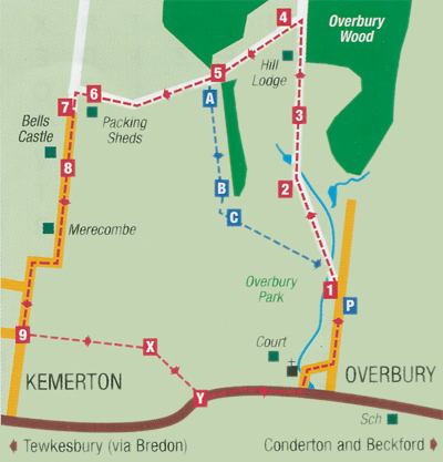
Park your car in Hill Road in the village of Overbury. This is the main village street which runs north from the road between Kemerton and Beckford. If parking close to the park gates, please bear in mind that the lane is frequently used by farm traffic, and access is required for heavy machinery. There may be sheep in Overbury Park, so please keep dogs on leads.
Walk through the park gates (1) crossing a stream, and keep following the tarmac road as it climbs the hill. To your right you can see mellow stone houses in a pleasing mix of styles and sizes, the majority of which belong to the Overbury Estate. The last cottages perched high up next to the wood formerly housed a silk mill; waterfalls which once supplied power now provide an attractive feature, tumbling down to a pond.
Go over a cattle grid (2) and continue to ascend. You will pass a another pond on your left, which is fed by a small stream that rises from a spring in the park. Overbury is self sufficient in water, with its own natural supply.
Keep on the tarmac road, over another cattle grid (3) passing Hill Lodge on your left. The trees from Overbury Wood now come down to the side of the lane on your right; after passing Hill Lodge's gateway, look for another gate on your left, and a track which virtually doubles back on the lane you have been walking on.
Go through the gate (4) and walk ahead. This is a cherry orchard, where fruit is abundant in early summer and often tantalisingly out of reach!
The views away to the left over the park take in Cleeve Cloud and the scarp of the Cotswolds heading down the Vale of Gloucester. Keep on the path beside the trees towards another gate (5), which is often locked. Climb over the style to the left of the gate, and ahead of you is a sandy track with views over Tewkesbury towards May Hill, with the Malverns to the right.
For the shorter route, look for footpath arrows on your left (A). Take the path back down the hill, keeping the trees on your left until you reach another farm gate (B). Go through the gate, trace a sunken grass path for a short distance, looking for the yellow footpath arrows on your left (C). Go through a further gate and descend the steep grass bank back to the park entrance, which you will see below you. For the longer walk, go straight ahead down the track, which is a permissive path leading to a stone barn known as the Packing Sheds (6). Bear left around the barn to a gate, and pass through a gap next to it on to a tarmac lane (7). As you descend, you will see an interesting building on your right (8). This is Bell's Castle, converted in the early 19th century from some old quarry workers cottages by a retired sea captain. It is reputed that Bell was actually a smuggler and continued his activities after he'd retired to this lofty spot, running brandy up the Severn and Avon to Bredon dock. Continue on down the lane, which has a rather steep descent, passing Merecombe House, then round sharp bends into the village of Kemerton. Keep walking down the lane (ignore the first turning to the right) until its junction with Wing Lane (9), the second turning on the right. More or less opposite is a gate into a field. Take this footpath and follow the arrows, keeping the hedge to left. Go through a small gate into another field (X) and walk diagonally to your right to another small gate, back on to the Kemerton to Overbury road (Y). Turn left, passing the Court's stone walls and St Faith's Church on the left, until you are back in the village.
- Car Parking - with respect to the residents access, in the village of Overbury.
- Distance - short route, 1.5 miles (from Overbury Park Gates); longer router 2.75 miles. Steady climb on good tracks through the park -
descents are steep in parts. - Refreshments - The nearest pubs are The Yew Tree at Conderton and the Crown at Kemerton.. Both welcome walkers and dogs and serve good food.
By Field and Hedgerow - Jack Walker
A slightly longer walk for 'a good stride out' without tackling unduly rough terrain .
 Park with care in the centre of Aston-on-Carrant and walk to the end of the village street.
Go through the gate into the yard and follow the footpath past the riding stable and paddocks (1). At the end of the first small field, go through the gate and walk ahead along a straight path with open fields to your right and the hedge on the left. Eventually you will reach the Cotswold stone Aston barn, and after passing the buildings the main bridleway bears left (2). Keep straight ahead and walk across a field towards a hedge.
Go through the gate, cross the lane with care and go through the five bar gate opposite (slightly to the left) and take the track known as the Worlies (3). Below you on the left is Carrant Brook, which for some of its length forms the county boundary between Gloucestershire and Worcestershire. This section of the walk is wholly in Worcestershire.
Keep along the trail, passing the pumping station, until you come to the edge of Beckford village (4). Turn left and walk along the road, passing the entrance to the manor house. When you reach the cross (note the mileages engraved on the stone post) bear slightly left and cross over into Court Farm Lane (5). Keep up the lane, which bears left just after a pond behind a stone wall, and carry on until you come to Court Farm. Follow the lane left, between the farm buildings. Do not take the lane which ascends Bredon Hill, but carry on along a stony track (with a sunken barn to the left) until you reach a road.
Turn right and walk up the road (which is busy and has no pedestrian pavement) until it bears sharply right (6). Go straight ahead along the private road which leads to Overbury Stud, and look for a gate with a yellow footpath marker leading into a paddock on the right.
Go through and walk diagonally across the Paddock towards a hedge, and pass through the gates. Follow the directional arrow to a five bar gate opening onto a drive. Walk past the stables and stud farm buildings on the right, until you reach a lane (7).
Cross over, go through a five bar gate into some paddocks, then into a large field via another farm gate. Keep the post and rail fencing to your right, passing a stile to meet a hedge. Walk with the hedge to the right until you reach a gate in it at the end of the field. Go through and bear left, then keep walking along a good track with the hedge to your right. Pass the turning to Robin's Mill and keep going until the lane dips down slightly, and there is a choice of paths at the edge of Kemerton village (8).
Turn left, keeping the hedge on your right, until you reach a small wood on the left (9). Walk ahead following the path over a large open field, towards a gap in a hedge (X). Some of this ground is soft and occasionally a diversion is in place; if so walk around the edge of the field until you reach the gap and go through it.
Carry on ahead, skirting an old gravel pit on the right. The two rickety stiles in place here may be on their last legs by now!After passing pit, bearslightly left and follow the path back towards Aston across the field (Y). Cross Carrant Brook by the footbridge, over a meadow then a paddock, and go back into the village via a path between some houses.
- Car Parking - Aston-on-Carrant village centre.
- Distance - 5.75 miles, mainly flat over generally good terrain. Dogs on leads in Stud Farm fields.
- Refreshments - The Queen's Head, Aston-on-Carrant.
- Notes - The route is waymarked with yellow (footpath) and blue (bridleway) arrows, but we recommend using OS sheet 190, our sketch map is for guidance only. Route not disabled friendly.
Following in Ancient Footsteps - Jack Walker
 Here's a walk to blow away the cobwebs and clear the head after the excesses of Christmas, and take in some of our best local scenery at the same time. Bredon Hill is steeped in history: last summer a hoard of some 3,700 Roman coins was found here and there are remains of ancient hilltop settlements 2,000 years old at its summit. The views from here can be spectacular on crisp, clear winter days - so it is well worth the climb.
Our walk starts from the Bredon Hill village of Overbury, some six miles east of Tewkesbury. Park near the church and walk up the main street, passing the village hall on your left.
Walk on past the entrance to Overbury Park and carry on ahead as the lane narrows and becomes steep (1). At the last cottage on the right, pass through a gate (usually open) into a field and follow the footpath on the left along the boundary wall, with the woodland behind it.
The path undulates for some distance, before dipping down at the end of the wood. Eventually you will cross a track (2) which leads to Park Farm away to the left.
Walk straight ahead over the field to reach another wood on your right hand side. At the end of the wood, you will meet a tarmac road (3) which leads to the radio mast (visible ahead of you). Turn left and follow the road until it bears down to Overbury Park at a cross track (which leads right to Lalu Farm).
Walk straight ahead with the fence on your left until you meet another footpath (5). Turn right and climb the hill until you reach a point where Lalu Farm is on your right. Turn left and follow the permissive path until you reach a stone-walled sheep fold (6).
Pass through the gate into the hill fort and head towards the stone tower, which now houses mobile phone equipment. The tower, known as Parson's Folly, was built as a summer house and the top of the structure is said to be exactly 1,000 feet above sea level.
Below the tower in the hollow to the right is the ancient Bambury Stone, also called the Elephant Stone because of its shape. On a clear day the panoramic view takes in Worcester and Gloucester cathedrals, the Malverns and Brecon Beacons, even as far as the Long Mynd range in Shropshire. Retrace your steps to point four, and turn right to descend on the tarmac private road through Overbury Park.
Keep following the drive down the hill, passing Hill Lodge, and cross two cattle grids. Between these, springs feed a stream which tumbles down the hillside: this water originally drove several mills in and around Overbury.
Emerge through the park gates (7), turning right to return to the village and St Faith's Church.
- Car Parking - by the church in Overbury, or with care near the entrance to Overbury Park.
- Distance - 4.75 miles, some steep ascents.
- Dogs - on leads within Overbury Park please, and wherever there are sheep cattle or game are in the fields.
- Refreshments - Nearest pubs are the Crown Inn at Kemerton or the Yew Tree at Conderton.
- OS Explorer Map - 190 recommended. Our sketch map above is not to scale and is for guidance only.
Around Dumbleton Hill - Jack Walker
 Like its near neighbour Bredon, Dumbleton Hill is an outlier of the Cotswolds. This particular route offers some lovely views of the surrounding vales and beyond - and although there is a steep ascent, which can be muddy at times, it is well worth the effort.
Park at the side of the road near the church. Walk along the main street, passing the tea shop and gallery, and take the first turning on the left, Dairy Lane (1). Walk to the end of the lane towards the cricket club, and look for a stile in a metal fence on the right (2). Cross the stileand follow the direction arrows across a small field, through a gate and up a hillside towards some woods. Go through the gate (3) and follow the path through the trees.
On your left you can see an overgrown ice house, which dates back
to the days when Dumbleton Hall was a fashionable private residence. It was acquired by the Post Office and used as a holiday hotel for employees for many years. It is now an upmarket hotel and popular wedding venue.
Follow the path as it exits the wood and skirts the edge of it. There are good views toyour right of Bredon Hill and the Vale of Evesham beyond. There are often cattle in the fields - and I have, in the past, encountered a bull here. Pass with caution!
Eventually you will meet a bridleway coming up from Didcot Farm(4). Turn left and follow the track as it climbs towards the edge of a wood.
Go through the gate (5) and follow the obvious path as it climbs steeply to the top of the hill. Parts of the bridleway here can become slippery and muddy after rain, particularly in winter months.
As you reach the top of the hill the path levels out and there are good views to the Cotswolds.
Go through the farm gate (6) on to a track on your left which leads to Hill Farm across the fields at the summit. Go through the gate to the right of the farm (7) and descend on the tarmac road through Dumbleton Park. The Hall may be seen on your left - and you might see the fountain in the ornamental pond too. At the bottom of the park, pass between some cottages (8), and take the lane ahead back to the church.
- Car Parking - near Dumbleton Church.
- Distance - approx 3.5 miles, one steep climb.
- Refreshments - Tea Room in Dumbleton; nearest pubs Queens Head, Sedgeberrow or Beckford Inn. Bar snacks and afternoon teas are also available at Dumbleton Hall.
- Our sketch map above is not to scale and is for guidance only.
In Winter time on Bredon - Jack Walker
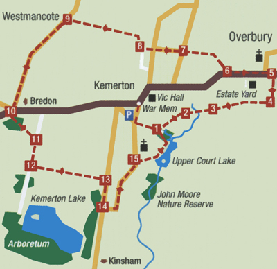 The lower slopes of Bredon Hill - an outlier of the Cotswolds - are ringed with charming villages. Many walkers merely pass through these streets of attractive cottages on their way to higher routes. this ramble takes time to look at three different villages, each with its own unique character.
Starting from the war memorial in the centre of Kemerton village, walk down the lane towards the church and at the cross roads, turn left. You will pass some farm buildings, and at the end of the tarmac road take the path through the trees.
At the bottom of the slope, turn left just before the stream and go through the five bar gate into a field (1).
The ground can be quite boggy here. Follow the path right across the field to a farm gate, go through and take the same line to cross a footbridge into the next field (2). Keep ahead and go over a stile, then yet another plank bridge and two more stiles to reach the lower grounds of Overbury Estate (3).
Overbury Court is visible away to your left. Go diagonally across the field towards the agricultural buildings in the Estate Yard. Go throught a kissing gate and follow the yellow way markers, passing some garages and up a slope past a wood store. At the end of the fence, turn left (4) up a track, passing some barns and into Overbury village.
On meeting the road (5)turn left, walk past the Church and a high stone wall. Cross to the right hand side of the road as you walk out of the village, and look for a metal gate on your right (6).
Go through the gate and follow the arrows across the filed to another small gate. Pass through it and walk ahead, keeping the hedge to your right. (temporary fences and gates are sometimes added to this field). Eventually you will meet a lane coming up from Kemerton (7).
Walk straight ahead down the lane, passing a farm on your right. At the next junction keep straight ahead into Bayliss Road, and look for a path in front of you, leading between some houses into a field (8). The path bears right then left, to skirt the right hand side of the field. Keep on this path, go through a gap in the hedge and keep the same line, eventually emerging on to the road in Westmancote (9).
Turn left and walk down through the village until you reach three way junction. Bear right along the road towards Bredon for a short distance, then corss opposite the bus shelter (10) and take a narrow path into some trees at the side of a bungalow. Keep following this path until you emerge through a small gate, cross a small plantation and meet a broader track (11). Turn right along this track, then left along another wide path with hedges either side (12). When you reach the road (13) turn right, then take the next road on the left back into Kemerton village (14).
This is Back lane, which wends its way gently upwards, with some fine old buildings along the way. After passing the black and white Old Manor, and then Kemerton Court, look for a small green with an attractive Georgian house set back to the right (15). Take the footpath between a cottoge and Upper Courts gardens (to the left), down to a small lake. The remains of an old cider mill can be seen here too.
Keep the lake to your right, and at the end of the bank go along the path into the trees, then over a footbridge to return to point (1).
- Car Parking - with respect to local residents in the centre of Kemerton village.
- Distance - just under 4 miles, flat.
- Refreshments - The Crown Inn, Kemerton.
- Map - Our sketch map above is not to scale and is for guidance only. OS sheet 190 is recommended.
Beckford's Hidden Gem - Jack Walker
 Beckford Nature Reserve is one of the hidden gems of Bredon Hill, writes Jack B. Walker. Tucked away near the centre of the village, the site is well managed by a team of volunteers and is run as a charitable organisation (Beckford Nature Reserve Ltd).
This month's walk, although short, offers the opportunity to observe a plethera of wildlife - and you may need to allow more time than you think!
Park your vehicle in the car park to the rear of the village hall. Leave the car park, cross the road and turn left along the lane (1). Take care as you walk the first five-ten minutes as there is no footpath and traffic is quite busy at times.
You will pass a cottage with stables on the opposite side of the road, then as the road bends sharply to the left, look for a lane on the right (SP: Bredon Hill), (2). Go along this lane towards some farm buildings. After passing a sunken barn on the right, the lane enters an old farm yard. Ignore the turning on the left (which ascends Bredon Hill) and walk ahead between the barns (3). At the end of the yard, bear right down the lane past Court Farn House on your right. This was formerly the home of the celebrated author of children's books, Ursula Moray-Williams (Gobbilino, the Witch's Cat!).
Walk on down the lane until you reach the edge of a copse on the left. Go up the steps on the left (5) in the gap between two fence posts to enter Beckford Nature Reserve. Follow the path down the timber steps to the lakeside. At the bottom, turn left and carry on around the lake (6).
A short distance further on you will come to a hide on your right. This affords an excellent view over the water: resident birds include Mallard, Coot, Moorhen, Tufted Duck and Dabchicks (Little Grebe) - you may hear the distant call of the latter. Canada Geese, Swans and Greylag Geese are also seasonal visitors.
For many years the Reserve was used as a sand and gravel quarry. Note the bank on the left just past the hide, which has been colonised by more seasonal visitors - Sand Martins - which are a delight to behold in spring. Rabbits have also taken over some of the burrows! Please do not approach this gravel face as it is unstable - and a Site of Special Scientific Interest (SSSI) because of its geology.
Follow the path from the hide towards the gate, and bear right up a slope to carry on around the lake (7). (To visit Beckford Silk, go through the gate, cross the road and follow the signs opposite).
Carrying on, you will emerge through the trees into a small private Orchard (8). Bear right and go through the gate at the end, keeping the lake to your right. Pass another hide (right) and a house (on the left), until you come to a kissing gate (9). Go through the gate and turn left. Follow the lane past another pond behind a stone wall.
Look for a narrow path to the left (X) between the pond and the first house, and take this to reach the churchyard. Follow the path past the Church (which is well worth a visit) and go through the lychgate.
Turn right (Y) and follow the road to the village cross, then bear right to return to the village hall.
- Car Parking - Behind Beckford Village Hall (free).
- Distance -1.75 miles.
- Refreshments - Beckford Sillk Coffe shop, Beckford Stores and Post Office or Beckford Inn (on A46).
- Map - Our sketch map above is not to scale and is for guidance only. OS sheet 190 recommended.
- Website - to find out more about Beckford Nature Reserve, visit their website -
This walk was published in The Times (April 3rd 2010) as one of their 'Walks in the woods'. Although not truly local to Beckford, a short drive to the Plough Inn at Ford - a popular pub for the residents of Beckford - takes you to the start of the walk.
Oldhill Wood and Lidcomb Wood, Stanton and Stanway, Gloucestershire.
Start: Plough Inn, Ford, Gloucestershire GL54 5RU (OS ref SP 089294)
Walk: 10 miles, 5 hours, OS Explorer OL45
Lunch: Mount Inn, Stanton (01386 584316: http://www.themountinn.co.uk)
Highlights: Racehorses training near Ford; views from Stenberrow hill fort; stone houses in Stanton and Stanway; Stanway House.
 If you go walking in the Cotswolds, you're going to meet horses, lots of them, and especially hereabouts, with Jonjo O'Neill's stables just over the hill at Temple Guiting. From Ford you meander north through tiny , Cutsdean and Taddington, before dipping among the oaks and chestnuts of Oldhill and Lidcombe Woods, alive with nesting and singing birds at this time of year (April). Linger in the ramparts of Shenberrow Hill to admire the long views from this Iron Age hill fort, before diving downhill to The Mount for lunch, a great pub with a view. Stanton and Stanway are the heavenly twins of the Cotswolds, villages of honey-golden stone where every house seems more worthy of "aaahs" than the next. The architect Sir Philip Stott bought the manor house of Stanton Court in 1906 and modernised, restored and protected his adoptive village with jealous care. As for Stanway, just down the valley, it boasts the grand Jacobean pile of Stanway House, with ranks of windows and an elaborate gatehouse. It is said that when J. M. Barrie was staying at Stanway House , she got inspiration for Peter Pan's fairy chum Tinkerbell when flashes of silvery moonlight, reflecting off the weather vane of the church, flickered across his bedroom wall.
Route: Cutsdean - Taddington - Oldhill Wood - Lidcombe Wood - Shenberrow hill fort - Mount Inn at Stanton - Stanway - Stumps Cross - Cutsdean - Ford
Warning: Undefined variable $doc_root in /home/theshieling/public_html/tourist/walks.php on line 297
Warning: include(/footer.html): Failed to open stream: No such file or directory in /home/theshieling/public_html/tourist/walks.php on line 297
Warning: include(/footer.html): Failed to open stream: No such file or directory in /home/theshieling/public_html/tourist/walks.php on line 297
Warning: include(): Failed opening '/footer.html' for inclusion (include_path='.:/opt/alt/php81/usr/share/pear:/opt/alt/php81/usr/share/php:/usr/share/pear:/usr/share/php') in /home/theshieling/public_html/tourist/walks.php on line 297